Cold Fusion Couloir
After a year of waiting, I got another chance to conquer the Cold Fusion Couloir, a steep, snow-filled gully that leads up the north face of Northern Timpanogos (11,441'). I went on the hike last year, but didn't make it to the top. So I've been training and preparing for this hike since then.
 After a scant 3 or so hours of sleep, I drove to our rendezvous at 106th South and then we carpooled up American Fork canyon to the Mutual Dell trail head. We started up the trail just before 4:30 am. The starry sky was glorious in the parking lot but before long we were in the forest and focused on only our next few steps as illuminated by our headlamps. After 70 minutes of climbing switchbacks, we came out to the level Forest Service road leads to the base of the couloir.
 Lighter shades of blue stretched across the eastern sky as we snowshoed across the quiet landscape.
 At the base of the couloir. The snow was pretty soft, so we decided to stick with our snowshoes (with ascenders up!) instead of strapping on crampons.
 This shot gives a feel for the steepness of the climb, often 45 degrees or greater. This is about the place where I switched to crampons.
 Trudging on up the snowy couloir, getting closer to the false summit.
 Dan, Jake, and Christine, just after finishing the long ascent up the couloir.
 Heading up to the false summit.
 Snow, strong winds, and freezing temperatures combine to form dangerous swirls of snow and ice that are cantilevered precariously over the leeward side of the mountain. From the windward side, it just looks like the top of the mountain, but were one foolish enough to walk up to the edge to peer over, their weight could be enough to break the cornice free and tumble down the mountain, likely triggering an avalanche on the slope below. Well, two in our party were mere feet away from a cornice just as it broke off. Others told horror stories of having one break beneath their feet and leaping to safety or hanging on for dear life by their ice axe. Needless to say, we steered clear of the cornices along the summit ridge.
 Coming from the false summit up to the true summit.
 After about 5h15m of hiking, we were treated to some spectacular views of Timpanogos from the summit.
 Our fearless leader, Michael Hannan, sets up his tripod for a group shot.
 Group shot taken on the summit at 9:45am--when I'd usually be just waking up on a Saturday morning!
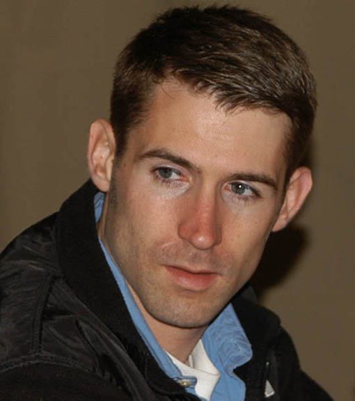
 I made it! Hooray!
 Coming back down the mountain. From this angle you can really see the cornices.

 The descent involved lots of plunge stepping down the couloir in deep, soft snow. And a little glissading for fun every now and then.
 The red line shows our approximate path to the summit. I believe this photo was taken from Box Elder Peak.
 At the end of the hike.
 After a scant 3 or so hours of sleep, I drove to our rendezvous at 106th South and then we carpooled up American Fork canyon to the Mutual Dell trail head. We started up the trail just before 4:30 am. The starry sky was glorious in the parking lot but before long we were in the forest and focused on only our next few steps as illuminated by our headlamps. After 70 minutes of climbing switchbacks, we came out to the level Forest Service road leads to the base of the couloir.
 Lighter shades of blue stretched across the eastern sky as we snowshoed across the quiet landscape.
 At the base of the couloir. The snow was pretty soft, so we decided to stick with our snowshoes (with ascenders up!) instead of strapping on crampons.
 This shot gives a feel for the steepness of the climb, often 45 degrees or greater. This is about the place where I switched to crampons.
 Trudging on up the snowy couloir, getting closer to the false summit.
 Dan, Jake, and Christine, just after finishing the long ascent up the couloir.
 Heading up to the false summit.
 Snow, strong winds, and freezing temperatures combine to form dangerous swirls of snow and ice that are cantilevered precariously over the leeward side of the mountain. From the windward side, it just looks like the top of the mountain, but were one foolish enough to walk up to the edge to peer over, their weight could be enough to break the cornice free and tumble down the mountain, likely triggering an avalanche on the slope below. Well, two in our party were mere feet away from a cornice just as it broke off. Others told horror stories of having one break beneath their feet and leaping to safety or hanging on for dear life by their ice axe. Needless to say, we steered clear of the cornices along the summit ridge.
 Coming from the false summit up to the true summit.
 After about 5h15m of hiking, we were treated to some spectacular views of Timpanogos from the summit.
 Our fearless leader, Michael Hannan, sets up his tripod for a group shot.
 Group shot taken on the summit at 9:45am--when I'd usually be just waking up on a Saturday morning!
 I made it! Hooray!
 Coming back down the mountain. From this angle you can really see the cornices.
 The descent involved lots of plunge stepping down the couloir in deep, soft snow. And a little glissading for fun every now and then.
 The red line shows our approximate path to the summit. I believe this photo was taken from Box Elder Peak.
 At the end of the hike.
posted by Ben at 1:34 PM
1 comments
![]()
![]()